Mumbai’s Red Line Metro Route: A Comprehensive Guide
To enhance civilian transportation access, the Mumbai Metropolitan Region Development Authority (MMRDA) embarked on an ambitious project to lay a 31.5 km long metro route known as the Red Line. This route aims to connect key areas such as Dahisar East, Mira Bhayandar, Andheri East, and the CSIA Terminal.
The Genesis of the Red Line Metro
Prime Minister Narendra Modi laid the foundation for this project in October 2015. The New Development Bank (NDB) and the Asian Development Bank (ADB) are partially financing the metro route through Official Development Assistance (ODA) loans.
Structure and Scope
The Red Line metro route in Mumbai, comprising lines 7, 7A, and 9, is a mix of underground and elevated tracks. The entire route spans 31.5 km and includes 23 station stops—7 elevated and 3 underground approved, with 14 elevated stations under construction.
Phase 1: A Milestone
Phase 1 of the Red Line metro route became accessible to the public in April 2022, connecting Dahisar East to Aarey via nine metro station stops. Line 7 was fully operational by January 2023. Once completed, the Red Line will interconnect with other major metro lines, bus, and rail services through numerous interchanges.
Key Details of the Red Line Metro Route
| City | Mumbai |
|---|---|
| Route | Red Line (7) |
| Total stops | 14 |
| Start station | Dahisar East |
| End station | Gundavali (formerly Andheri East) |
| Distance | 16.4 KM |
| Operating time | 6:00 AM to 10:30 PM |
Metro Stations on the Red Line
Running at an approximate speed of 80 km/hr, Mumbai’s Red Line route (7) operates every 10 to 12 minutes. Currently, only ten elevated stations out of the fourteen are operational, covering Dahisar East to Aarey. The Red Line 7 will eventually extend to Mira Bhayandar at Metro Line 9 and CSMIA International Airport as Metro 7A.
Operational Stations
- Dahisar East
- Ovaripada
- Rashtriya Udyan
- Devipada
- Magathane
- Poisar (formerly Mahindra & Mahindra)
- Akurli (formerly Bandongri)
- Kurar (formerly Pushpa Park)
- Dindoshi (formerly Pathanwadi)
- Aarey
- Goregaon East (formerly Mahanand)
- Jogeshwari E (formerly JVLR junction)
- Mogra
- Gundavali (formerly Andheri East)
According to data posted on June 11, 2023, by Maha Metro Mumbai Operation Corporation Limited (MMMOCL), the total number of passengers on the Mumbai Metro Lines 2A and 7 has crossed the 3 crore mark. On the Metro 7 line, Devipada is the least used station, while Gundavali is the most frequented.
Red Line: Faster Commutes
A well-routed metro line significantly eases commuter travel. The Red Line metro route allows passengers to travel from CSIA Terminal 2, Mira Bhayandar, Dahisar East, and Andheri East with 23 stations, including significant city stops. The Red Line also connects with the Green Line at the Miragaon Station terminal.
Red Line: Reliable Transit Solution
The Red Line metro has three phases. Line 7 at Dahisar connects to Mira Bhayandar (N) at Line 9. In the south, the Andheri line connects to CSMIA Terminal 2 as Metro Line 7A. Collectively, Lines 7, 7A, and 9 are known as the Red Line metro in Mumbai.
Top Attractions and Nearest Stations
| Top attractions | Nearest station with distance |
|---|---|
| Mandapeshwar Caves | Ovari Pada - 2.5 km |
| Sanjay Gandhi National Park | Rashtriya Udyan - 450 m |
| NL Garden | Dahisar East - 700 m |
| Essel World | Rashtriya Udyan - 950 m |
| Aksa Beach | Aarey - 240 m |
| Vaghdevi Waterfalls | Ovari Pada - 650 m |
Future Expansion of the Red Line Metro Route
As of 2022, only one phase of the Red Line metro project (Red Line 7) has been inaugurated. The next steps involve constructing the Red Line Route 7A, which will run from Andheri East to CSIA Terminal 2, and Route Line 9 from Dahisar East to Mira Bhayandar. Once completed, the Red Line metro route will be 31.05 km long and have 23 stations.
Red Line 7 Metro Route Map
For the Red Line Route 7 in Mumbai, the starting station is Dahisar East, and the journey ends at Gundavali (formerly Andheri East). The metro line has 14 stops, out of which four are still under construction. The active ten stops cover the journey from Dahisar East terminal to Aarey. The metro leaves at a frequency of around 12 minutes.
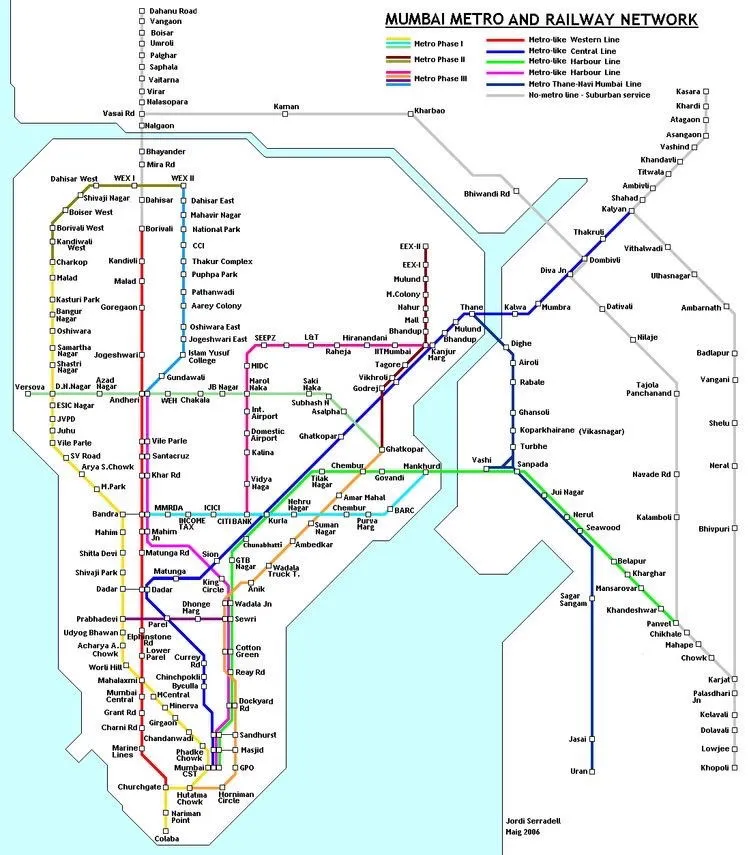
Source: Pinterest
Construction Information
In 2015, the Delhi Metro Rail Corporation (DMRC) signed a deal with MMRDA for the development of Line 7. The Mumbai metro’s Red Line route is planned to be 31.05 km long with 23 stations. The MMRDA owns the Red Line metro. In 2019, they established a new department called Maha Mumbai Metro Operations Corporation (MMOCL) to maintain and oversee all metro route services.
The Asian Development Bank (ADB) and New Development Bank (NDB) are financing the project under ODA loans. The Prime Minister laid the foundation stone in October 2015, and the project began. In September 2018, Maharashtra’s government approved extending the metro routes to CSIA Terminal 2 (Line 7A) and Mira Bhayandar (Line 9), with a total cost of Rs 6,518 crore.
The first phase was completed on April 2, 2022, and the Prime Minister inaugurated Route Line 7. The Red Line Route 7 is 16.5 km long and connects Aarey to Dahisar East with nine stations in between, all fully operational. The line will have an additional five elevated stops ending in Andheri East, all under construction. The line’s primary color (red) was made public on February 28, 2020. The entire construction is expected to be finished by December 2024.
Schedule and Timings
The Red Line 7 metro route runs daily from Dahisar to Aarey with nine stops, as the other five are still under construction. Its daily timings are from 6 AM to 10 PM.
- The first train from Dahisar East leaves at 6:00 AM.
- The frequency of the trains is 10-12 minutes.
- The last train from Dahisar leaves at 10:30 PM.
- The first train leaves from Aarey at 6:00 AM.
- The last train to depart from Aarey is at 9:24 PM.
| Day | Operating hours | Frequency |
|---|---|---|
| Sunday | 6:00 AM to 10:30 PM | 10-12 mins |
| Monday | 6:00 AM to 10:30 PM | 10-12 mins |
| Tuesday | 6:00 AM to 10:30 PM | 10-12 mins |
| Wednesday | 6:00 AM to 10:30 PM | 10-12 mins |
| Thursday | 6:00 AM to 10:30 PM | 10-12 mins |
| Friday | 6:00 AM to 10:30 PM | 10-12 mins |
| Saturday | 6:00 AM to 10:30 PM | 10-12 mins |
Sustainable Transportation
The Red Line metro fare is charged according to the distance traveled by a commuter.
- For 3-12 km: Rs 20
- For 12-18 km: Rs 30
- For 18-24 km: Rs 40
- For 24-30 km: Rs 50
Commuters who use the metro services daily can buy electronic smart cards from authorized channels. They only need to pay Rs 50 for the card, which allows 45 trips for 30 days. The ticketing is managed by paper or mobile QR-based tickets as of now.
Contact Details
Mumbai Metropolitan Region Development Authority (MMRDA) BANDRA-KURLA COMPLEX MMRDA OFFICE BUILDING, C-14 & 15, E BLOCK BANDRA (EAST), MUMBAI – 400 051 Phone: +91-22-26594000 Fax No.: +91-22-2659 1264
Conclusion
The Red Line metro route in Mumbai is a significant step towards improving the city’s transportation infrastructure. With its extensive network and future expansions, it promises to offer a reliable and efficient transit solution for millions of commuters. Whether you’re traveling to work, visiting tourist attractions, or simply exploring the city, the Red Line metro is set to make your journey smoother and faster.