
Ram Setu Showtimes: Unveiling the Mysteries of Adam’s Bridge
There are only a few historical structures across the globe that link mythological and historical theories together. One such construction is Adam’s Bridge, also known as Ram Setu. Recently, the central government approved an underwater exploration to study the structure and determine the age of the Ram Setu and its formation. This study will also help in understanding if the structure is as old as the Ramayana period. Also, there is a demand to make Ram Setu a national monument, although the matter is sub-judice. With this, it becomes more interesting to know if there are possibilities to link Indian mythology with modern-day structures.
What is Ram Setu?
The Ram Setu bridge is a chain of natural mineral shoals between Pamban Island or Rameswaram Island in Tamil Nadu, India, and Mannar Island in Sri Lanka. The bridge has great significance as per Hindu mythology and is mentioned in the Ramayana. The structure has also intrigued scientists as studies are being undertaken to determine the age of the Ram Setu bridge.
Moreover, an upcoming Indian movie will be based on Ram Setu. The story will revolve around an archaeologist trying to find if the Ram Setu bridge is a myth or a reality.
Here is everything interesting that you need to know about Adam’s Bridge.
Ram Setu Bridge: Quick Facts
| Name of the bridge | Ram Setu, Adam’s Bridge |
|---|---|
| Location | Pamban Island, Rameswaram Island in Tamil Nadu, India, and Mannar Island in Sri Lanka |
| Length | 48 kilometers (km) |
| Age | 7000 years |
ISRO Scientists Create First Undersea Map of Complete Ram Setu Bridge
Using data from a US satellite, Indian space scientists at the Indian Space Research Organisation (ISRO) have come up with a detailed map of the Ram Setu Bridge with the objective of resolving the long-standing controversies on its origin. The mapping exercise has led to the creation of an undersea map of the entire 29 km bridge, showing its height as eight meters from the seabed.
The surveying exercise used a US satellite to reflect laser beams off the sea floor, which showed that 99.98% of the bridge, a 29-km stretch of limestone shoals, is under shallow waters.
The researchers used ICESat-2 data from October 2018 to October 2023 to generate a 10-meter resolution map of the full length of the submerged ridge, which is sufficient to capture details of the size of a train coach.
As per the findings, the ridge is around eight meters above the seabed over most of its length. However, only around 0.02% of the volume is accessible or visible and the remaining is submerged. Limestone is formed from the fossils of sea life. Over millions of years, marine animals’ shells and skeletons accumulate on the ocean floor, pushing down on one another to form solid rock.
Ram Setu Bridge (Adam’s Bridge): Proven Facts
Ram Setu or Adam’s Bridge is a structure akin to a causeway, connecting Pamban Island in Tamil Nadu to Mannar Island in Sri Lanka. The total length of the bridge is approximately 50 km. Adam’s Bridge also separates the Gulf of Mannar from the Palk Strait. Some of the sandbanks are dry. The sea around this structure is very shallow, ranging from three ft to 30 ft deep.
According to several scientific reports, the bridge was completely above sea level till 1480 but was damaged by a cyclone that hit the area. Till the 15th century, Ram Setu distance was passable on foot until the channel deepened.
After the cyclone struck the region, even ships can no longer navigate in this sea stretch in the Indian Ocean, known as the Palk Strait, as the seabed is too low. However, hundreds of years later, the thin land strip re-emerged from the water, leading to the creation of several small islands and sand banks, redefining the geography of Asia.
See also: All about Chittorgarh Fort, India’s largest fort
There is geological evidence to prove that the bridge was earlier a land connection between India and Sri Lanka. There are studies that show that the bridge is made of limestone shoals and is a linear sequence of coral reefs. There is also proof that it is made of floating rocks found scattered across Rameswaram and there are theories that believe volcanic rocks do float on water.
The Pamban Island can be accessed from the Indian mainland by the two-km-long Pamban Bridge. As the sea water near the coral reef is very shallow, navigation of ships is impossible, because of which ships have to take roundabout routes, to reach Sri Lanka.
The Sethusamudram Project was proposed, to provide a shortcut route from Pamban Island to Mannar Island in Sri Lanka. However, environmentalists say that the project could destroy the natural reefs, which had existed for thousands of years. Although the Sethusamudram Project was planned to be executed by deepening the Pamban pass, so that the Rama Sethu could also be preserved, the project is still at a standstill.
Oceanography research suggests that the bridge is 7,000 years old. This tallies with the carbon dating of beaches near Mannar Island and Dhanushkodi.
As per one theory that proves the truth about Ram Setu, the Palk Strait and Gulf of Mannar were part of the Kaveri River basin. Owing to tectonic shifts, the outline of the area including Rama Setu Bridge formed, and the shapes of these landforms resulted in coral growth.
According to the Marine and Water Resources Group of the Space Applications Centre (SAC) of the Indian Space Research Organisation (ISRO), the Ram Setu Bridge comprises 103 small patch reefs.
How Deep is the Ram Setu Bridge?
The bridge is submerged in water. It is around 100 meters wide and up to 10 meters in depth.
See also: Mother Of Thousands
Ram Setu Bridge Age
According to the Geological Survey of India, around 7,000 to 18,000 years ago, Rameswaram and Talaimannar islands were above the water. Some evidence, including coral dating, suggests that Ram Setu was formed about 500-600 years ago. It is a natural formation and people could walk on it until the 15th century. As per records, it was above sea level until 1480. However, natural disasters later covered the bridge in the shallow sea.
Ram Setu: Transport Corridor
The Ram Setu Bridge offered a land connection between India and Sri Lanka during the time of lowered sea level for the last 100,000 years. Owing to shallow waters, the bridge provided hindrance to navigation through the Palk Strait. Trade activities across the India – Sri Lanka boundary have been taking place since at least the first millennium BC, it was limited to small boats and dinghies.
In 1823, Sir Arthur Cotton surveyed the Pamban channel, that divides the Indian mainland from the island of Rameswaram and forms the first link of Ram Setu bridge. As per geological evidence, a land connection bridged this in years ago. According to some records of Ramanathaswamy Temple violent storms damaged the link in 1480.
Cotton suggested that the channel must be dredged to allow the passage of ships but no action was taken. However, in 1828, Major Sim directed the blasting and removal of some rocks. In 1837, a detailed marine survey of the Ram Setu Bridge was carried out and operations to dredge the route were recommended the following year. Despite these efforts, the passage could not be made navigable for vessels except those with a light draft.
What NASA Says About Ram Setu?
According to NASA and images captured by satellite, there are a naturally occurring chain of sandbanks. It says that the photos taken by its astronauts do not prove the existence or otherwise of a man-made bridge, as specified in the Ramayana.
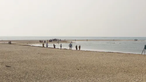
Where is the Ram Setu Visible From?
The Ram Setu bridge is visible from Dhanushkodi, a town in Rameshwaram, Tamil Nadu. It is around 20 km from Rameshwaram. To reach this place, one must cross over to the Pamban Island, which is accessible by train through the Pamban Bridge.
See also: Pamban Bridge Rameshwaram: Fact guide, latest update
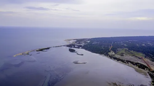
Ram Setu Images
Check these real images of Ram Setu bridge.
Source: Wikimedia Aerial view of Ram Setu
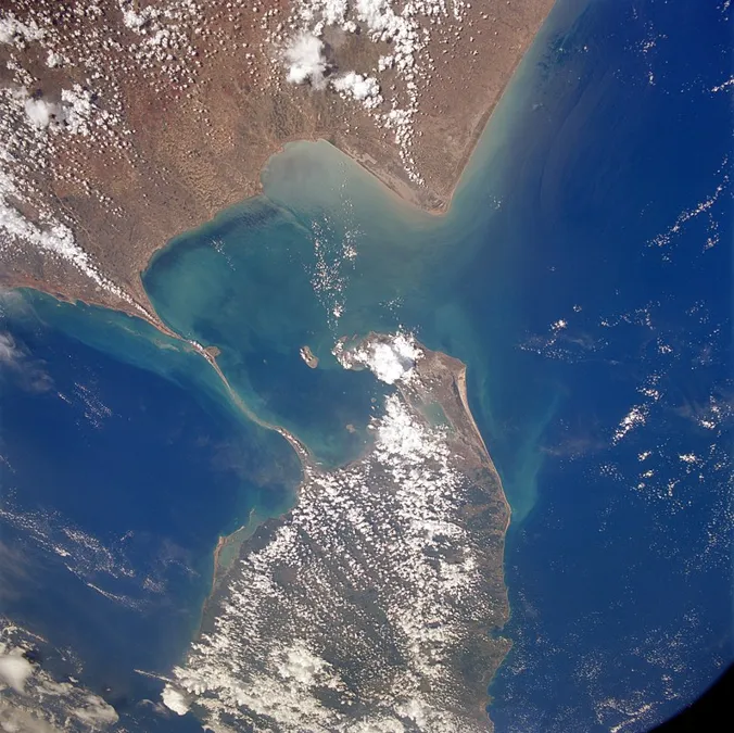
NASA satellite image of Ramsetu bridge Source: Wikimedia
Ram Setu Bridge: Mythological Significance
Ram Setu was first mentioned in Valmiki’s Ramayana, a Hindu epic. The Ramsethu bridge is believed to have been built by Lord Rama’s Vanara Sena, with instructions from Nala, for Lord Ram to reach Lanka to rescue his wife Sita. According to legend, the bridge was built using floating stones, with the name of Lord Rama engraved on it, which made it unsinkable. Apparently, Lord Rama prayed to the ocean, for a path from India to Lanka, so that he could go and rescue Sita from the clutches of Ravana, the king of Lanka.
As per Ramayana, 7th century BCE to 3rd century CE, the Ram Setu bridge was constructed by Lord Ram, with the help of an army of Vanaras (monkeys), led by Lord Hanuman, to reach Lanka.
Also read all about Daulatabad Fort: An imposing structure with historical significance
Ram Setu, also known as Ramsethu, Adam’s Bridge, Nala Setu, and Setu Banda, is the only archaeological and historical evidence of Ramayana. According to Hindu mythology, Ram Setu is a holy site. Therefore, no bridge should be built over it.
In Hinduism, it is widely believed that Lanka mentioned in the Ramayana is the present-day Sri Lanka and the Ramsethu bridge was built by Lord Rama. However, as per Sanskrit sources of the first millennium, there is a distinction between the two and this belief was widely promoted especially during the rule of the Chola dynasty of south India who sought to invade the island before it was co-opted by the Aryacakravarti dynasty in Jaffna who claimed to be guardians of the bridge. As per several scholars, the original Lanka was on the eastern side of present-day Madhya Pradesh.
Is Lanka the Present Day Sri Lanka?
As per popular belief, Lanka is equated to the present-day Sri Lanka. However, there are a few verses in Ramayana that may be held to be against such an identification and some Sanskrit sources highlight the distinction. Further, two reputed medieval commentaries on the Ramayana Ramanujiya by Ramanuja and Tattvadipika by Mahesvaratirtha make a distinction between Lanka and Sri Lanka.
Ram Setu Bridge: Strategic Significance
During the 19th century, the British planned to dredge the Ram Setu channel length to allow the navigation of big ships along the Indian coast or enable travel between the east and west coasts. The plans did not succeed. However, the project has been revived as the Sethusamudram project.
Ram Setu Bridge: Mysterious Facts About the Structure
The debate between whether Rama Setu is a man-made bridge has been going on for several decades. However, the bridge has several other surprising facts about it and they are the following:
- Ram Setu is also known as Adam’s bridge or Nala Setu. The former name derives its origin from an Islamic text that mentions the presence of Adam’s peak in Sri Lanka. It is also called Nala Setu because Nala was the architect who designed the bridge in Ramayana.
- The beaches’ carbon dating and oceanographic studies reveal a time frame that coincides with the time frame of Ramayana.
There have been several opinions about the history and truth behind the Ram Setu bridge. According to one theory, there was an actual land connection between India and Sri Lanka during the Ice Age. As per another theory, Sri Lanka was considered a part of the mainland Indian subcontinent. It was believed to have broken away around 1,25,000 years ago.
Is Ram Setu Really Man-Made?
There are a lot of studies to know if Rama Setu is real and researches that are trying to understand the true nature of this structure. Recently, Raj Bhagat Palanichamy, who works as a GIS and remote sensing analyst at World Resources Institute, tweeted satellite animations explaining the formations between India and Sri Lanka.
#Thread: Since many had asked this, Writing a short thread on the formation between India and Sri Lanka Usually many get deceived by “static” satellite images and believe that the Tombolo section as permanent relics of a man made bridge. pic.twitter.com/TEzvgwqnTc
— Raj Bhagat P #Mapper4Life (@rajbhagatt) July 7, 2020
Deeper ocean currents don’t enter the section between Sri Lanka and India because of the Cont Shelf. The sea surface in this section is dominated by longshore currents in two directions – one from Gulf of Mannar and other from Palk strait and they are in opposite directions pic.twitter.com/TyyDmklhSL
— Raj Bhagat P #Mapper4Life (@rajbhagatt) July 7, 2020
Longshore currents bring a lot of sediments. And at the meeting point of the currents they settle and form these islands. Notice in the satellite images below how these islands change a lot owing to current direction, tides, etc. This is just a short term timelapse (<4 years) pic.twitter.com/pkMJuVHcm5
— Raj Bhagat P #Mapper4Life (@rajbhagatt) July 7, 2020
The sediment deposition is a gradual process and has been happening over long time. In the last 30 years, we can notice the changes in the Pamban Island near Dhanushkodi where the islands in deeper section had been volatile whereas sand closer to Pamban have been consolidating pic.twitter.com/ENrBSm9Del
— Raj Bhagat P #Mapper4Life (@rajbhagatt) July 7, 2020
The sediment accretion and erosion is not limited to the section between Rameshwaram and Mannar, deposition has been happening close to the group of islands between Thoothukudi and Mandapam. There is also a spit formation in Kodikarai which has formed Muthupet salt marshes pic.twitter.com/NSLRgqMQJB
— Raj Bhagat P #Mapper4Life (@rajbhagatt) July 7, 2020
What these tell is that these formations are caused by the sea n are not manmade. The desc/location of bridge as mentioned in epics don’t match this either The future of this Tombolo is dependent on Sea level, Currents etc. It might either consolidate in future or might be lost!
— Raj Bhagat P #Mapper4Life (@rajbhagatt) July 7, 2020
Why is Ram Setu Known as Adam’s Bridge?
The bridge first appeared in Ibn Khordadbeh’s Book of Roads and Kingdoms (c. 850), in which it is referred to as ‘Set Bandhai’ or ‘Bridge of the Sea’. Other sources describe this bridge in the context of Adam, crossing over to India from Sri Lanka via the bridge, after his expulsion from the Garden of Eden, leading to the name of Adam’s Bridge. A mountain in Sri Lanka was referred to as the Adam’s Peak where Adam was believed to have fallen to earth. This was described by Al Beruni, an Iranian scholar who lived around 1030 CE.
Apart from this, a British cartographer, in 1804, prepared the earliest map that calls this area by the name Adam’s Bridge. This was in reference to one Abrahamic myth according to which Adam used the bridge to reach a mountain that was identified by the British as Adam’s Peak in Sri Lanka. Here, Adam stood repentant on one foot for nearly 1,000 years that this left a hollow mark that looked like a footprint.
Further, the ancient text Tārīkh al-Hind written by Al-Biruni was known to be the first to use the name, Adam’s Bridge.
Ram Setu Expedition
The Ram Setu expedition was carried out in March 2021 by scientists and