Bangalore Metro: A Comprehensive Guide to Connectivity
Bangalore, the bustling IT hub of India, was the first city in southern India to introduce metro rail connectivity. The Bangalore Metro, also known as Namma Metro, has significantly transformed the city’s transportation landscape. Let’s dive into the details of this extensive metro network, its current status, and future plans.
The Inception of Bangalore Metro
When the Bengaluru Metro was inaugurated, it marked the beginning of the first underground metro system in South India. The network comprises underground, at-grade, and elevated metro stations, managed by the Bengaluru Metro Rail Corporation Limited (BMRCL). This joint venture between the Government of India and the Karnataka government is responsible for building, operating, and expanding the metro network in Bangalore.
Recent Developments
On October 9, 2023, BMRCL opened the Namma Metro’s 43-km Purple Line, connecting Challaghatta to Kadugodi (Whitefield). This new section, which includes 37 stations, bridges the gap between the eastern and western parts of the city, taking around 80 minutes to cover the total distance.
Major Expansion Plans
Bangalore Metro is set to witness a significant expansion with a proposed 129-km addition under Phase-4. This expansion aims to enhance connectivity in suburban areas, addressing the lack of sufficient metro links in the city’s core regions.
Proposed New Corridors
According to a Times Now report, the BMRCL has obtained state government approval to conduct feasibility studies for five additional metro corridors:
- Challaghatta to Bidadi (15 km)
- Silk Institute to Harohalli on Kanakapura Road (24 km)
- Madavara to Kunigal Cross near Nelamangala (11 km)
- Bommasandra to Attibele (11 km)
- Kalena Agrahara to Kadugodi Tree Park via Jigani Attibele and Varthur (68 km)
New Metro Lines and Extensions
The BMRCL’s new plan includes a new metro line and extensions of the existing Purple and Green lines in four directions: Bidadi (Mysuru Road), Harohalli (Kanakapura Road), Attibele (Hosur Road), and Kunigal Cross (Tumakuru Road, near Nelamangala). The proposed new semicircular line will connect localities such as Jigani, Anekal, Attibele, Sarjapur, and Varthur, focusing on the city’s east and south.
Namma Metro Phase 3
Work on Namma Metro Phase 3 is expected to begin this year, comprising three metro corridors with a total length of 81.12 km. The Metro 3A project has received approval from the state finance department, and BMRCL will soon begin land acquisition work.
Geotechnical Investigations
BMRCL has announced the commencement of geotechnical investigations for the upcoming phase, valued at Rs 6 crore. The addition of two new elevated metro lines covering 45 kilometers is expected to boost connectivity across the city.
Upcoming Metro Stations in Bangalore
New Routes on Namma Metro
| Line | Terminals | Expected work completion date |
|---|---|---|
| Purple Line | Challaghatta – Whitefield | October 2023 |
| Green Line | Nagasandra – Madavara (previously BIEC) | January 2022 |
| Yellow Line | Rashtreeya Vidyalaya Road – Bommasandra | March 2022 |
| Pink Line | Kalena Agrahara (previously Gottigere) – Nagawara | June 2024 |
| Blue Line | Central Silk Board – KR Puram | June 2026 |
| Blue Line | KR Puram – Kempegowda International Airport | June 2026 |
Future Metro Corridors
According to an action plan prepared by the Karnataka department of planning, program monitoring, and statistics, and the Federation of Indian Chambers of Commerce & Industries (FICCI), the Karnataka government plans to introduce four new Metro corridors by 2032 under Phase 3 of the Bangalore Metro Rail project. The proposed new metro lines are expected to provide Metro access to every citizen within 1-2 km from their workplaces or homes.
Proposed Metro Corridors
Developed at the cost of Rs 27,000 crore, the proposed Metro corridors include:
- Old Airport Road, from MG Road to Hope Farm via Marathahalli and Whitefield/ IT corridor (underground), covering 16 km, with an estimated cost of Rs 9,600 crore
- Nagawara to Kempegowda International Airport (KIA) via Thanisandra/ Bharatiya City, covering 25 km, with an estimated cost of Rs 10,000 crore
- A 6-km Metro extension from Whitefield to Katamanallur / Hoskote, at an estimated cost of Rs 2,400 crore
- A 12-km extension of Bannerghatta line to Jigani at an estimated cost of Rs 4,800 crore
Other Proposed Lines in Bangalore
| Line | Terminals |
|---|---|
| Purple line extension | Whitefield – Hoskote (6 km) |
| Pink line extension northwards | Nagawara – KIAL Terminals via Thanisandra 25 km |
| Pink line extension southwards | Kalena Agrahara – Jigani 12 km |
| Yellow line extension along Hosur road | Bommasandra – Hosur |
Operational Metro Routes in Bangalore
| Metro line | Route | Distance | Stations |
|---|---|---|---|
| Line-1 Purple Line | Challaghatta – Whitefield (Kadugodi) | 42.17 km | 37 |
| Line-2 Green Line | Nagasandra – Silk Institute | 30 km | 29 |
Namma Metro Construction
The Bangalore Metro was designed and conceptualized by the Delhi Metro Rail Corporation (DMRC). The first line was opened to the public in October 2011, after years of delay. The project, currently in expansionary mode, is being executed by the Bengaluru Metro Rail Corporation Limited (BMRCL). The average daily ridership on the Namma Metro network is 5,18,000 as per data last updated in January 2020.
Namma Metro Phase 1
Bangalore’s Namma Metro Phase 1 included two lines of length of 42 kms, of which about 8.82 kms is underground and the remaining is elevated. There are 40 stations in this phase. The foundation stone for construction of Phase 1 was laid in June 2006 and the construction began between Baiyyappanahalli and Mahatma Gandhi Road in April 2007. The phase was later expanded to include the northern extension (from Yeshwanthpur to Nagasandra) and southern extension (from Rashtreeya Vidyalaya Road to Yelachenahalli).
Cost
The final cost for developing Namma Metro Phase 1 was estimated to be Rs 14,405 crore while the land acquisition is around Rs 2,500 crore.
Namma Metro Phase 2
Approved in January 2014 by the union cabinet, the estimated cost for the second phase of Namma Metro was Rs 26,405 crores, which is estimated to escalate to Rs 32,000 crores in due time. Phase 2 spans a length of 72 kms, out of which 13 kms is underground. This phase has 62 stations out of which 12 are underground. Bengaluru Metro Phase 2 includes extension of the two Phase 1 lines in both directions, as well as construction of two new lines.
Key Extensions
- The south-end of the Green Line will be extended from Yelachenahalli to Anjanapura along Kanakapura Road and from Nagasandra to Madavara (previously named BIEC) on Tumkur Road.
- On the Purple line, the east-end has been extended from Baiyappanahalli to Whitefield and from Mysore Road to Challaghatta via Kengeri.
RV Road to Bommasandra
A new, 18-km-long, fully-elevated line from RV Road in south Bangalore to Bommasandra in the southeast via Electronic City is also planned in the second phase. The metro line is expected to be operational by December 2023.
Kalena Agrahara (Gottigere) to Nagawara
Another 21-km-line from Kalena Agrahara (previously Gottigere) to Nagawara is also under process. The route will have an elevated corridor, covering a distance of 7.5 kms with six stations and an underground stretch of 13.76 kms from south ramp near Jayanagar Fire station to north ramp at Nagawara consisting of 12 underground stations.
Namma Metro Phase 2A (Blue Line)
A new line between Silk Board and KR Puram has been included in Phase 2 as Phase-2A of the project. This line would run along the Outer Ring Road and is proposed to have 13 stations – Silk Board, HSR Layout, Agara, Ibbalur, Bellandur, Kadubeesanahalli, Kodibisanahalli, Marathahalli, ISRO, Doddanekundi, DRDO Sports Complex, Sarasvathi Nagara (previously Mahadevapura) and KR Puram.
Namma Metro Phase 2B (Airport Line)
To connect Kempegowda International Airport with MG Road, Namma Metro Phase 2B is under-construction, which will be built at a cost of Rs 10,584 crores. The route will be 39 kms long. The route would begin at Krishnarajapura (KR Puram) and will be aligned along the northern part of ORR (Outer Ring Road), via Nagawara, Hebbal and Jakkur, before heading towards the airport.
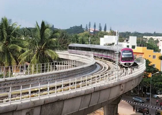 Image Credit: http://bit.ly/23WGhCp
Cost
The total cost of Phase 2 is estimated around Rs 26,405 crore. Land acquisition is expected to cost around Rs 5,000 crore. The state and central governments will contribute 30% and 20% of the total project cost, respectively. The remaining will be obtained through senior term loans.
Namma Metro Phase 3
In March 18, 2024, the Karnataka cabinet gave a nod for the commencement of construction work for Bangalore Metro Phase 3. The Bangalore Metro Phase 3 project, which will be developed at an estimated cost of Rs 15,611 crore, is expected to be completed by 2028. Bangalore Metro Phase 3, which will cover a distance of 44.65 km, will come up along the entire stretch of the Outer Ring Road (ORR).
Proposed New Metro Routes
- Carmelaram to Yelahanka, covering 37 kms
- Marathahalli to Hosakerehalli, covering 21 kms
- Bommasandra to Attibele
- Gottigere to Basavanapura
- RK Hegde Nagar to Aerospace Park
- Kogilu Cross – Rajanukunte
- Iblur to Carmelaram
Metrolite Lines
In 2020, the government announced that two corridors will be developed as metrolite lines, under public private partnership (PPP) model. These include ORR West Line of 30 kms: Hebbal to Mysore Road Metro Station and Magadi Road Toll Gate to Kadabagere section covering 14 kms.
Comprehensive Mobility Plan
In December 2019, the BMRCL introduced a Comprehensive Mobility Plan for subsequent phases. This includes the following routes under Phase 3:
- Magadi Road Toll gate to Kadabgere (Metrolite) (12.5 km)
- Hebbal to Sarjapura (35 km)
Hosahalli Metro Station
Hosahalli Metro Station (on Magadi road from Toll gate) to Kadabagere will be an elevated with nine metro stations. It is expected to be completed in 2028.
Cost
The estimated cost of the two corridors (J P Nagar to Kempapura and Hosahalli-Kadabagere) project is nearly Rs 13,500 crore. A new corridor of 35 km from Hebbal to Sarjapura will taken up under Phase-3B, estimated to cost around Rs 15,000 crore. The state government will bear 80 to 85% cost of the metro project. Around 13 to 15% is likely to be borne by the Centre.
Bangalore Metro Phase 4
New metro stations along the following routes will come up under Phase 4 as per the Comprehensive Mobility Plan:
- JP Nagar to Hebbal Kempapura (32.15 km)
- Whitefield to Domlur (31 km)
- Inner Ring UG Metro (34 km)
According to media reports, the BMRCL has sought funds from the state government to conduct a feasibility study on the proposed metro lines under Namma Metro Phase 4.
Namma Metro Purple Line
The stretch from Mysuru Road to Kengeri became operational on August 30, 2021. The Purple Metro Line is a 42.5-km route connecting Challaghatta with Whitefield (Kadugodi), providing smooth connectivity between the eastern and western parts of the city. Mostly elevated, it has a 4.8-km underground section in the middle and passes through some of the prime areas of Bengaluru including MG Road, Majestic, Railway Station, Vidhana Soudha, etc. The journey from Challaghatta in the south-west and Kadugodi (Whitefield) in the east will take around 76 minutes.
Namma Metro Purple Line Stations
| Station | Transit / interchange |
|---|---|
| Whitefield | Whitefield railway station/Kadugodi Bus Stand |
| Channasandra | |
| Kadugodi | |
| Pattandur Agrahara | |
| Sadaramangala | |
| Nallurhalli | Whitefield TTMC |
| Kundalahalli | |
| Sitharama Palya | |
| Hoodi Junction | |
| Garudacharpalya | |
| Mahadevapura | |
| Krishnarajapuram | Blue Line (Planned, Ph-2A)/KR Puram Railway Station |
| Benniganahalli | |
| Baiyappanahalli | Baiyappanahalli Railway Station |
| Swami Vivekananda Road | |
| Indiranagar | |
| Halasuru | |
| Trinity | |
| MG Road | Pink Line (UC) |
| Cubbon Park (Sri Chamarajendra Park) | |
| Dr BR Ambedkar Station, Vidhana Soudha | |
| Sir M Visvesvaraya Station | |
| Nadaprabhu Kempegowda station, Majestic | Green Line/KG Bus Station City Railway Station |
| City Railway Station | City Railway Station |
| Magadi Road | |
| Balagangadharanatha Swamiji Station, Hosahalli | |
| Vijayanagara | |
| Attiguppe | Vijayanagar TTMC |
| Deepanjali Nagara | |
| Mysore Road | Orange Line(Planned, Phase lll) |
| Nayandahalli | |
| Rajarajeshwari Nagara | |
| Jnanabharathi | Jnanabharathi |
| Pattanagere | |
| Mailasandra | Kengeri TTMC |
| Kengeri Bus Terminal | |
| Challaghatta |
Namma Metro Yellow Line
The Bangalore metro’s yellow line route will connect RV Road to Bommasandra along an elevated route, covering a distance of 19.14 kms. It will comprise a total of 16 metro stations. The BMRCL plans to open the Yellow Line, which connects RV Road to Bommasandra, in one go by December 2023.
Namma Metro Yellow Line Stations
| Station Name |
|---|
| Rashtreeya Vidyalaya Road (RV Road) |
| Ragigudda |
| Jayadeva Hospital |
| BTM Layout |
| Central Silkboard |
| Bommanahalli (formerly HSR Layout) |
| Hongasandra (formerly Oxford College) |
| Kudlu Gate (formerly Muneshwara Nagar) |
| Singasandra (formerly Chikkabegur) |
| Hosa Road (formerly Basapura Road) |
| Beratena Agrahara (formerly Hosa Road) |
| Electronic City |
| Infosys Foundation Konappana Agrahara (formerly Electronic City – II) |
| Huskur Road |
| Hebbagodi (Hebbagodi Depot of 39.3 acres) |
| Bommasandra |
Namma Metro Pink Line
The pink line is among the future metro projects in Bangalore that will boost the connectivity in the city. This section will span a distance of about 21 kms and connect Kalena Agaraha (formerly Gottigere) to Nagawara. There will be an elevated route of 7.5 kms and an underground stretch of 13.8 kms. There are a total number of 18 metro stations planned in this metro line.
Namma Metro Pink Line Stations
| Station Name |
|---|
| Kalena Agrahara (formerly Gottigere) |
| Hulimavu |
| IIM-Bangalore |
| JP Nagar 4th Phase |
| Jayadeva Hospital |
| Swagath Road Cross |
| Dairy Circle |
| Lakkasandra (foremerly Mico Industries) |
| Langford Town |
| Rashtriya Military School (formerly Vellara Road) |
| MG Road |
| Shivaji Nagar |
| Cantonment |
| Pottery Town |
| Tannery Road |
| Venkateshpura |
| Kadugundanahalli (formerly Arabic College) |
| Nagawara |
Once operational, the Pink Line metro route will connect key areas of the city and is expected to boost economic prospects in the region.
Namma Metro Green Line
The Bangalore Metro Green Line connects Nagasandra in the north-west to Anjanapura in the south-west. It covers a distance of 30 kms and has 30 stations. Like the Purple Line, this is also mostly elevated on both, the north and south sides and has a four-km underground section in the middle. The line has 26 elevated metro stations and three underground stations. Bangalore Metro Green Line passes through industrial areas such as Peenya, Yeshwanthpur in the north and connects it with the residential areas such as Basavanagudi, Jayanagar, Banashankari, etc. The Green Line is also being expanded till Madavara in the north-west and Silk Institute in the south. With this, the length of the line will increase to 33.5 kms.
Namma Metro Green Line Stations
| Station name