Chennai Metro: A Comprehensive Guide to Meenambakkam Metro and Beyond
The Chennai Metro has revolutionized urban transportation in Chennai, making it one of the most connected cities in India. With the recent developments and expansions, including the Meenambakkam Metro, the network continues to grow, enhancing connectivity and impacting the real estate market positively. Let’s dive into the details of the Chennai Metro, its inception, phases, routes, and its broader impact on the city.
The Latest Development: ADB Loan Agreement
On December 3, 2023, the government signed a $350-million loan agreement with the Asian Development Bank (ADB) to build new lines for the Chennai Metro Rail network. This is part of a $780-million multi-tranche financing facility approved by ADB on December 8, 2022, aimed at developing three new metro lines in Chennai—Lines 3, 4, and 5.
Chennai Metro: Key Facts
Chennai boasts an operational metro rail network that has significantly improved connectivity in the Tamil Nadu capital. The Chennai Metro is the third-longest metro rail network in India, following Delhi and Hyderabad. It has not only enhanced transportation but also positively impacted the city’s real estate market.
Inception of Chennai Metro
The planning for the Chennai Metro project began in 2007 when the Tamil Nadu government sanctioned Rs 50 crore to launch the mass transit network project. The Delhi Metro Rail Corporation (DMRC) was brought on board to prepare a detailed project report. The Tamil Nadu cabinet approved the project, and the Chennai Metro Rail Corporation (CMRC) was incorporated to execute it. The central government approved the Chennai Metro Rail Limited (CMRL) project on January 28, 2009, and actual work began in June 2009, starting with a metro rail link between Koyambedu and Ashok Nagar under Phase-1.
Launch of Chennai Metro
The Chennai Metro opened to the public on June 29, 2015, with the inauguration of a 4.5-kilometre stretch between Alandur and Koyambedu stations. On September 21, 2016, services began between the Chennai International Airport Metro Station and Little Mount.
Estimated Cost of Chennai Metro
The estimated cost of the Chennai Metro project is Rs 14,600 crore, including escalation, central taxes, and interest during construction, but excluding state taxes and the value of vacant state government land. The central and state governments are expected to contribute about 41% of this cost, with the remaining amount coming from a loan from the Japan International Cooperation Agency (JICA). A loan agreement was signed between the governments of India and Japan on November 21, 2008, in Tokyo.
Chennai Metro Phase-1
Under Phase-1, two corridors with a combined length of 45 km were constructed. Of this, 24 km of the metro rail network is underground, while 21 km is elevated. The 22-km-long second corridor runs from Chennai Central to St Thomas Mount via Koyambedu. The CMRL projects connect key junctures and major transport hubs, including Chennai Central, Chennai Egmore, Central Mofussil Bus Terminal (CMBT), Chennai Airport, St Thomas Mount, Guindy, Government Estate, and the High Court.
Chennai Metro Route: Phase-1 Corridor-1
The 23.1-km-long first corridor, also known as the Chennai Metro Blue Line, runs from Washermanpet to the Airport via Anna Salai. Under this corridor, 17 metro stations have been proposed. The first 11 stations are underground, while the remaining are elevated.
Phase-1 Corridor-1 Stations
- Washermanpet Metro
- Mannadi
- High Court
- Central Metro
- Government Estate
- LIC
- Thousand Lights
- AG-DMS
- Teynampet
- Nandanam
- Saidapet Metro
- Little Mount
- Guindy Metro
- Alandur
- Nanganallur Road
- Meenambakkam Metro
- Chennai Airport
Chennai Metro Route: Phase-1 Extension
In 2015, a 9.05 km extension to the existing Chennai Metro Blue Line network was approved under Phase-1 extension. At an estimated cost of Rs 3,770 crores, this extension covers the distance between Sir Thiyagaraya College and Wimco Nagar, with eight metro stations along the way. The Phase-1 extension became operational in February 2021 and contributes nearly 20% of the metro service’s total ridership.
Phase-1 Extension Stations
- Sir Thiyagaraya College
- Tondiarpet
- New Washermenpet
- Tollgate Metro
- Kaladipet Metro
- Thiruvottiyur Theradi
- Thiruvottiyur
- Wimco Nagar
Chennai Metro Route and Stations: Phase-1 Corridor-2
The second corridor, also known as the Chennai Metro Green Line, includes the following 17 stations:
- Central Metro
- Egmore Metro
- Nehru Park
- Kilpauk
- Pachaiyappa’s College
- Shenoy Nagar
- Anna Nagar East
- Anna Nagar Tower
- Thirumangalam
- Koyambedu
- CMBT
- Arumbakkam
- Vadapalani
- Ashok Nagar
- Ekkattuthangal
- Alandur
- St Thomas Mount
The first nine stations on this stretch are underground, while the remaining are elevated.
Chennai Metro Map – Phase 1
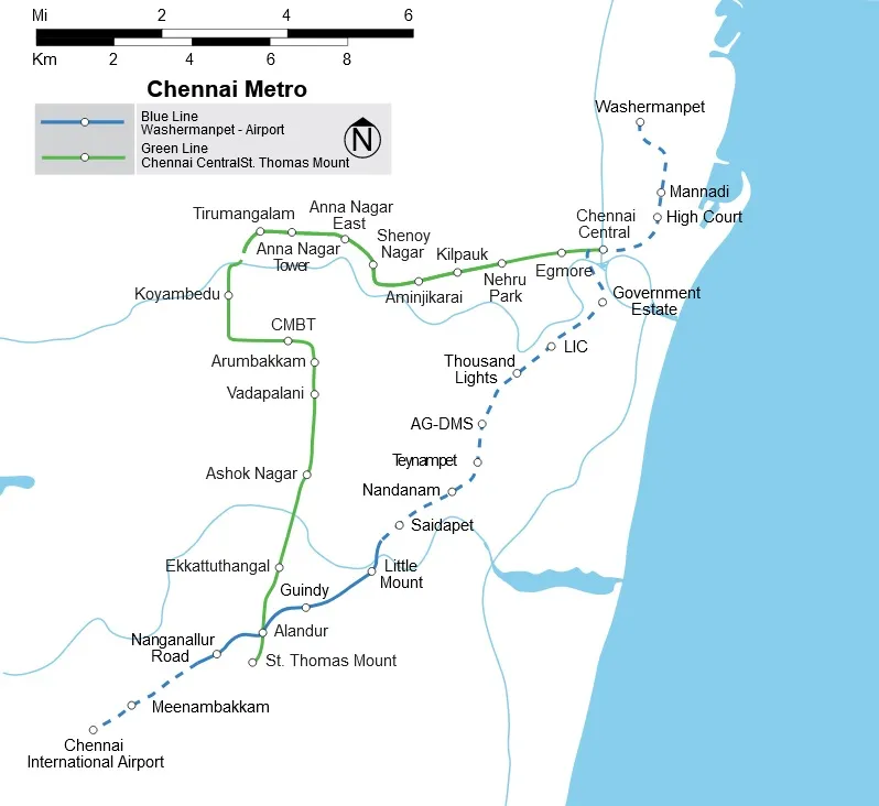
(Source: Wikimedia Commons)
Chennai Metro Phase-2
Under Phase-2, the state proposes to build three additional corridors—Corridor 3, Corridor 4, and Corridor 5. To be built at an estimated cost of Rs 61,843 crores, Phase-2 will cover a total distance of 109 km, expanding the connectivity network to key suburban areas. Construction work for this phase was expected to start in 2019, with completion projected for 2026.
Chennai Metro Corridor-3 Route and Stations
Corridor 3 will start at Madhavaram Milk Colony and end at St Joseph College. The stations include:
- Madhavaram Milk Colony
- Thapalpetti
- Murari Hospital
- Moolakadai
- Sembiyam
- Perambur Market
- Perambur Metro
- Ayanavaram
- Otteri
- Pattalam
- Perambur Barracks Road
- Doveton Junction
- Purasawalkam High Road
- Kellys
- KMC
- Chetpet Metro
- Sterling Road Jn
- Nungambakkam
- Gemini
- Thousand Lights
- Royapettah Government Hospital
- Radhakrishnan Salai Jn
- Thirumayilai Metro
- Mandaveli
- Greenways Road Metro
- Adyar Jn
- Adayar Depot
- Indira Nagar
- Thiruvanmiyur Metro
- Tharamani Link Road
- Nehru Nagar
- Kandanchavadi
- Perungudi
- Thoraipakkam
- Mettukuppam
- PTC Colony
- Okkiyampet
- Karapakkam
- Okkiyam Thoraipakkam
- Sholinganallur
- Sathyabama
- St Joseph College
Chennai Metro Corridor-4 Route and Stations
Corridor 4 will have the following 30 stations:
- LightHouse
- Kutchery Road
- Thirumayilai Metro
- Alwarpet
- Bharathidasan Road
- Adyar Gate Junction
- Nandanam
- Natesan Park
- Panagal Park
- Kodambakkam Sub Urban
- Meenakshi College
- Power House
- Vadapalani
- Saligramam
- Avichi School
- Alwarthirunagar
- Valasaravakkam
- Karambakkam
- Alapakkam
- Porur Junction
- Chennai Bypass Crossing
- Ramachandra Hospital
- Iyyappanthangal Bus Depot
- Kattupakkam
- Kumananchavadi
- Karayanchavadi
- Mullai Thottam
- Poonamallee bus terminus
- Poonamallee Bypass
- Poonamallee Bus Depot
Chennai Metro Corridor-5 Route and Stations
Corridor 5 will have the following 18 stations:
- Madhavaram Milk Colony
- Venugopal Nagar
- Assisi Nagar
- Manjambakkam
- Velmurugan Nagar
- MMBT
- Shastri Nagar
- Retteri
- Kolathur
- Srinivasa Nagar
- Villivakkam Metro
- Villivakkam Bus Terminus
- Nadhamuni
- Anna Nagar Depot
- Tirumangalam
- Kendriya Vidyalaya
- Kaliamman Koil Street
- CMBT
Chennai Metro Fare
In February 2021, the CMRL reduced the maximum metro fare by Rs 20, from Rs 70 to Rs 50, while maintaining the minimum fare at Rs 10 for a travel distance of 2 km. The new fare structure is as follows:
- Rs 20 for a distance of 2 km to 5 km
- Rs 30 for a distance of 5 km to 12 km
- Rs 40 for a distance of 12 km to 21 km
- Rs 50 for distances beyond 21 km
A 20% discount is provided to those booking tickets using the QR code or CMRL smart cards.
Chennai Metro Timings
The Chennai Metro operates from 5:30 am to 11:00 pm from Monday to Saturday, with a headway of 5 minutes during peak hours and 10 minutes during non-peak hours.
Impact on Connectivity
Before the Coronavirus pandemic, the CMRL carried about 1.15 lakh passengers a day on average, with a train available every five minutes during peak hours. Post-pandemic, this number has reduced to 65,000 a day. As the CMRL expands under Phase-2, a large part of Chennai will be connected through the metro network, including areas currently lacking regular mass public transit like Old Mahabalipuram Road (OMR) and East Coast Road (ECR).
Impact on Housing Market
Cities with established metro networks see value appreciation in housing markets that become better connected. According to a report by property brokerage JLL India, land values within 500 meters of metro rail corridors and upcoming corridors are expected to increase by 10%-15% in cities like Chennai. The residential prices surged from Rs 3,600 per sq ft to Rs 7,000 per sq ft after the CMRL Phase-I became operational in 2019. The demand for retail and office spaces around metro stations has also seen a spike, with commercial and retail rental prices along the 100-ft road of the CMRL increasing by about 50% to 70%.
Conclusion
The Chennai Metro, with its extensive network and continuous expansions, has significantly improved urban transportation in Chennai. The recent developments, including the Meenambakkam Metro and the ADB loan agreement, promise further enhancements in connectivity. As the metro network grows, it not only facilitates easier commutes but also positively impacts the real estate market, making Chennai a more attractive city for residents and investors alike.